|
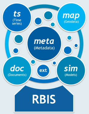
Jakarta River Basin Information System Jakarta River Basin Information System (JakartaRBIS) is a web-based information system focused on time series and geospatial of hydro-geo-meteorological data in the western part of Java Island, Indonesia. JakartaRBIS provides user interface for data input and output, powerful visualization components and an adaptable set of functions for data analysis, data management and data enrichment. The hydro-geo-meteorological datasets are rainfall, air temperature, relative humidity, sunshine hours, wind speed, river runoff, landuse/landcover, geological data, soil type distribution and topographic detail derived from a Digital Elevation Model (DEM). JakartaRBIS is developed by Department of Geoinformatics, Hydrology and Modelling (DGHM), Friedrich-Schiller University (FSU-Jena), Germany. Hydrometeorological data is obtained from Climatology, Meteorology and Geophysics Agency, Indonesia and Water Research and Development Department, Ministry of Public Works, Indonesia. JakartaRBIS is a part of PhD research supported by Directorate General of Higher Education, Ministry of National Education, Republic of Indonesia under Debt Swap Indonesian-German Doctoral Scholarship (IGDS) program. A detailed documentation of how to use JakartaRBIS can be found here. |
|