Input
Processing Input data
Preview File Size Date Comment
190.4 kB 2016-02-29 viewshed calculated from track
(Input)
Geodata (9/9)
1. VGTB Land Cover 2010 v1 VGTB_2010Landcover_0311.tar.gz
LUCCI_deliverable_DEO_Land_Use_Map.pdf
Legend_for_ArcGIS9.zip
2. Soil (province Da Nang & Quangnam_DN) Soil_QN_DN_110810.zip
3. Project area (27.9.2011) Project_area_27_09_2011.zip
4. Geology (LUCCi project area) Geology.zip
5. VGTB LandCover 2010 v2 - Updated Land_Cover_2010_updated.zip
VGTB_LandCover_2010_v2_Report.pdf
6. VGTB Land Cover 2001 and 2005 VGTB_LandCover_2001_2005.zip
7. DGM 25m (Vu Gia Thu Bon) DEM_NEU.zip
8. Database Topographic Maps Quang Nam
9. River system riversystem.tgz
Time series metadata (40/40)
1. Da Nang precipitation
2. Tra Mi precipitation
3. Trao precipitation
4. Nong Son precipitation
5. Hoi Khach precipitation
6. Ai Nghia precipitation
7. Giao Thuy precipitation
8. Hoi An precipitation
9. Cau Lau precipitation
10. Cam Le precipitation
11. Vinh Dien precipitation
12. Kham Duc precipitation
13. Que Son precipitation
14. Tien Phuoc precipitation
15. Thang Binh precipitation
16. Son Phouc precipitation
17. Ba Na precipitation
18. Hiep Duc precipitation
19. Duc Bo precipitation
20. Duc Phu precipitation
21. Son Tan precipitation
22. Tam Ky precipitation
23. Hien (Trao) precipitation
24. Thanh My Precipitation
25. Ai Nghia Precipitation
26. Cam Le Precipitation
27. Cau Lau Precipitation
28. Da Nang Precipitation
29. Giao Thuy Precipitation
30. Hien (Trao) Precipitation
31. Hiep Duc Precipitation
32. Hoi An Precipitation
33. Hoi Khach Precipitation
34. Kham Duc Precipitation
35. Nong Son Precipitation
36. Tien Phuoc Precipitation
37. Tien Sa Precipitation
38. Tra Mi Precipitation
39. Tram Bo Sung Precipitation
40. Precipitation Tr Hy
Output
Preview File Size Date Comment
869.7 kB 2016-02-29 
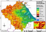
Omit error method with 9 input factors
953.5 kB 2016-02-29 
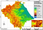
Omit error method with 13 input factors
1.2 MB 2016-02-29 
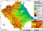
Statistical Index method with 13 input factors
1012.3 kB 2016-02-29 
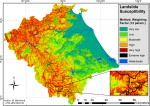
Weighting Factor method with 13 input factors
538.0 kB 2016-02-29 
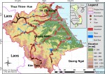
viewshed and landslides used
3.5 MB 2016-02-29 
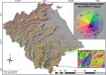
aspect and slope input factors
110.9 kB 2016-02-29 
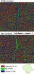
curvature input factors
737.1 kB 2016-02-29 
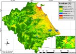
landuse input factor
1.0 MB 2016-02-29 slope and roads input factors
505.1 kB 2016-02-29 various input factors
168.3 kB 2016-02-29 SPI and TWI input factors
Geodata (5/5)
1. Landslides mapped landslides_mapped.tgz
2. Landslide susceptibility Statistical Index method stat_index.zip
3. Landslide susceptibility Weighting Factor method wf_13fac.zip
4. Landslide susceptibility Omit error method oe_13fac.zip
5. Landslide susceptibility Omit error method (9 input factors = best result) oe_9fac.zip